The solar energy industry in the United States is booming, with the U.S. Energy Information Administration projecting that the percentage of electric capacity additions from solar will grow to 71% in 2025 (51 GWAC). However, before constructing a new solar power plant, the site’s resources must be thoroughly assessed for feasibility, bankability and operational excellence.
Solar power plant performance relies not only on sunshine but also on accurate weather data since weather conditions directly affect the performance of PV panels. Consequently, with a thorough solar resource and weather assessment, solar power developers and asset owners can maximize their investment.
The importance of solar resource assessment
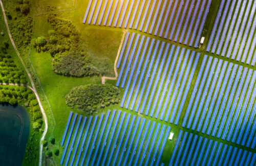 Involving the collection and analysis of solar irradiance and weather data, solar resource assessments determine the amount of solar energy available at a particular site and the location’s potential for generating electricity.
With accurate data on solar irradiation components, albedo, temperature, soiling, humidity, wind velocity and rainfall, project owners and operators can simulate the project and derive energy yield estimates for informed decision-making.
The amount of sunlight the solar panels receive — diffuse or direct — is the primary factor determining the energy generated. According to National Renewable Energy Laboratory (NREL), higher albedo values increase annual PV energy by up to 8%, and panels cleaned once or twice yearly produce 3.5% and 5.1% more electricity than uncleaned ones. Still, solar panel efficiency decreases as the temperature increases. Developers must also consider the wind speed damaging threshold to avoid damages while recognizing that wind cools panels, increasing efficiency, and that rainfall data helps estimate the cleanliness of the modules.
Solar resource assessments play a crucial role in selecting suitable sites, choosing technical equipment, sizing systems and optimizing yields, so accurate solar irradiation and weather data is essential for several reasons:
- Financial planning and investing: Investors and lenders require reliable estimates of a project’s energy yield and economic returns to make informed decisions about financing. Inaccurate solar resource data can lead to overestimated or underestimated predictions, jeopardizing the project’s bankability.
- System sizing and configuration: Solar resource assessment data is used to optimize the design of the solar power plant, including the selection of equipment, the layout of the panels and the sizing of the system components. Incorrect data can lead to suboptimal system designs and reduced energy production.
- Risk mitigation: Understanding solar resource variability and potential uncertainties (such as weather patterns) allows for better risk management, helping identify potential challenges and develop contingency plans to reduce financial risks and enhance project resilience.
- Performance optimization: During the operational phase, solar irradiance and weather data are crucial for monitoring the performance of the solar power plant and identifying any deviations from expected energy yield. Accurate data enables timely corrective actions and maximizes the plant’s operational efficiency.
Inaccurate solar data impacts stakeholders at each stage of the project life cycle. For developers, a low-quality assessment will affect long-term performance, and thus the P50 and P90 estimates, possibly making the financial indicators less attractive. For the EPC, inaccurate solar data can reduce the PR, potentially leading to liquid damage, long performance discussions and even payment delays. For the O&M, inaccurate solar data could lead to unnecessary interventions on-site, with each visit costing about $1,000. For asset owners, an incorrect PR could make any asset degradation undetectable, which — in an example case of just 2% at a 5-MW plant over five years — resulted in a revenue loss upward of $70,000.
Understanding different data collection methods is important given the challenges surrounding irradiance measurements — shading, tilt, orientation and environmental impacts — and sensor- and system-related monitoring challenges like communication loss, power loss and calibration.
Solar irradiance and weather data collection
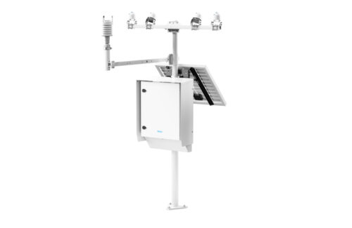 Two primary methods for collecting solar irradiance and weather data are on-site measurements and satellite-based models.
- On-site sensor measurements: On-site measurements involve the installation of ground-based sensors and weather stations at the proposed site. These sensors measure various parameters, including global horizontal irradiance (GHI), direct normal irradiance (DNI), diffuse horizontal irradiance (DHI), air temperature, wind speed and other relevant meteorological data.
- Satellite-based and reanalysis models: Using remote sensing data from Earth observation satellites and weather condition reanalysis, these models estimate solar irradiance and weather conditions at almost any location on Earth. Satellite information relies on algorithms that combine satellite imagery with meteorological data and other inputs to generate solar resource estimates.
On-site sensors provide highly accurate and granular data, essential for precise energy yield predictions and performance monitoring. Often referred to as “the ground truth,” these measurements also account for local topography, terrain and microclimatic conditions and can be used to verify and calibrate satellite-based models.
On the other hand, satellite-based models provide global coverage, making the data suitable for assessing solar resources, and typically represent a more cost-effective approach. By providing solar resource estimates for periods spanning decades, satellite data enables the analysis of long-term climatic trends.
With a clear understanding of the significance of collecting precise solar resource data and its uncertainty, adhering to the optimal assessment strategies can help maximize solar project return on investment, or ROI.
Best practices for solar resource assessment
 To obtain the most accurate ground measurement data with the lowest uncertainty, the following best practices are recommended:
- Select locations with unobstructed access to sunlight, minimal shading and suitable space for solar panel installation. Consider factors like orientation, tilt angle and local weather patterns.
- Check the leveling and alignment of high-quality weather observation systems — like Vaisala’s AWS810 Solar Edition weather station — frequently cleaning the instrument optics depending on on-site conditions, dust, snow, birds and instrument type. Recalibrate sensors as necessary.
- Combine at least one year of on-site measurements and satellite data for the most comprehensive and accurate solar resource data. On-site measurements can validate and calibrate satellite data, while satellite data can fill gaps and provide long-term historical context.
- Follow industry standards and guidelines, such as the World Meteorological Organization’s CIMO Guide, the U.S. NREL Best Practices Handbook for the Collection and Use of Solar Resource Data for Solar Energy Applications and the International Electrotechnical Commission’s IEC 61724-1:2021 standard, for sensor selection, installation, maintenance and data quality control.
- Utilize advanced analytics tools and platforms that integrate various data sources, perform data quality checks and provide detailed energy yield predictions and performance analysis, identifying potential issues and recommending corrective actions.
- Document everything — system design, site installation, all preventive and corrective maintenance actions, observational data QC, etc. — to maintain quality control.
Combining satellite data with on-site observational data modelled through advanced global services like Vaisala Xweather improves the accuracy and spatial and temporal resolution of solar resource assessments, thereby reducing resource uncertainty. In fact, GHI, DNI and DHI percentages all dropped 1.81, 3.21 and 4.85 over 24 months of observation, respectively.
Evolution of the solar industry
Determining the feasibility of a solar energy project requires extensive consideration, including site selection, system sizing and configuration, energy yield optimization, financial planning and investing, risk mitigation, and grid integration. Critical factors like location, climate, topography and shading must be analyzed throughout the project’s life cycle to make informed decisions on its design, financing and operation.
As the solar industry continues to grow, accurate solar resource assessment will remain critical in derisking investments, ensuring project bankability and optimizing energy yields — paving the way for profitable and high-performing solar assets.
By combining on-site measurements with satellite-based models, adhering to industry standards, employing advanced analytics and continuously monitoring and optimizing the system, solar developers and asset owners can maximize their ROI and contribute to a sustainable energy future.
 Dr. Rémy Parmentier is the Head of Solar and Hybrid at Vaisala Renewable Energy, where he leads Vaisala’s solar energy business strategy offerings and development. Having joined Vaisala Leosphere in 2006, he led the WindCube lidar R&D team for more than a decade, actively demonstrating the benefits of lidar technology worldwide. Dr. Parmentier holds a PhD in Physics from the University of Aix-Marseille in France.


Tell Us What You Think!